File:Orographical map of the Dardanelles reduced from captured Turkish maps.jpg
From Wikimedia Commons, the free media repository
Jump to navigation
Jump to search

Size of this preview: 411 × 600 pixels. Other resolutions: 164 × 240 pixels | 329 × 480 pixels | 526 × 768 pixels | 702 × 1,024 pixels | 10,507 × 15,328 pixels.
Original file (10,507 × 15,328 pixels, file size: 27.23 MB, MIME type: image/jpeg)
File information
Structured data
Captions
Add a one-line explanation of what this file represents
Captions
Summary[edit]
| DescriptionOrographical map of the Dardanelles reduced from captured Turkish maps.jpg |
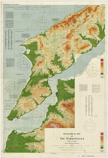
English: First World War orographical (topographical) map, on 2 sheets, of the Dardanelles, Turkey, with relief shown by colour shading and contour lines. Has some descriptions of land quality and use and gives magnetic variation. Includes reference of Turkish words with English equivalencies. Reduced from captured Turkish maps and annotated with location names used by the Allied forces. Scale 1:50000.
See Gallipoli Campaign. |
| Date | |
| Source | State Library of New South Wales Map Z/M3 390.8/1915/2, Mitchell Map Collection |
| Author | Egypt. Maslahat al-Misahah; Great Britain. War Office. General Staff. Geographical Section |
| Derivation | Merge of two digitised map sheets, Digital Order Nos. a5807001 a5807003, colour match and join Brass razoo 2014 |
| Other Sources | National Library of Australia Map 238, Ferguson Collection |
| Camera location | 40° 12′ 00″ N, 26° 24′ 00″ E | View this and other nearby images on: OpenStreetMap |
|---|
Licensing[edit]
| Public domainPublic domainfalsefalse |
This image is of Australian origin and is now in the public domain because its term of copyright has expired. According to the Australian Copyright Council (ACC), ACC Information Sheet G023v17 (Duration of copyright) ().3
When using this template, please provide information of where the image was first published and who created it. català | Deutsch | English | español | français | македонски | മലയാളം | Nederlands | русский | slovenščina | Türkçe | українська | +/− |
||||||||||||||||||||
File history
Click on a date/time to view the file as it appeared at that time.
| Date/Time | Thumbnail | Dimensions | User | Comment | |
|---|---|---|---|---|---|
| current | 01:23, 10 March 2014 |  | 10,507 × 15,328 (27.23 MB) | Brass razoo (talk | contribs) | sharper original |
| 01:48, 4 March 2014 |  | 10,289 × 14,960 (21.87 MB) | Brass razoo (talk | contribs) | User created page with UploadWizard |
You cannot overwrite this file.
File usage on Commons
The following 2 pages use this file:
File usage on other wikis
The following other wikis use this file:
- Usage on ar.wikipedia.org
- Usage on az.wikipedia.org
- Usage on bs.wikipedia.org
- Usage on ca.wikipedia.org
- Usage on de.wikipedia.org
- Usage on el.wikipedia.org
- Usage on en.wikipedia.org
- Usage on es.wikipedia.org
- Usage on nl.wikipedia.org
- Usage on tr.wikipedia.org
- Usage on www.wikidata.org
Metadata
This file contains additional information such as Exif metadata which may have been added by the digital camera, scanner, or software program used to create or digitize it. If the file has been modified from its original state, some details such as the timestamp may not fully reflect those of the original file. The timestamp is only as accurate as the clock in the camera, and it may be completely wrong.
| Image title |
|
|---|---|
| Author | Egypt. Maslahat al-Misahah.;Egypt : General Staff. Geographical Section;Brass razoo |
| Short title |
|