Simple measurement of length by using fingers and hands or by pacing, illustrated in one of Gemma Frisius's editions of Peter Apian's Cosmographia.
From Peter Apian & Gemma Frisius, Cosmographia, sive descriptio universi orbis (Antwerp, 1584)
Figure 3
The use of a mathematical instrument, the astronomical rings, to measure the height of a tower.
Illustrated in Jean Taisnier, De annuli sph�rici fabrica & usu (Antwerp, 1560)
Gemma Frisius at his desk surrounded by instruments and books.
From Gemma Frisius, Arithmeticae practicae methodus facilis per Gemma Frisium medicum ac mathematicum, (Antwerp, 1540).
Figure 5
Horoscope prepared for the birth of Gemma Frisius.
The title-page of Arithmeticae practicae methodus facilis per Gemma Frisium medicum ac mathematicum (Antwerp, 1540).
Figure 7
A page from a manuscript now in the Bodleian Library, by Michael Coignet.
Coignet is described on the title-page as 'Michaelis Coign�ti Mathematici Antwerpiani'. The title is 'De regulae pantometrae (iam recens ab illo inventae) fabrica & usu' and the instrument concerned is a form of sector, which can be fitted with sights and a magnetic compass and which can be mounted on a tripod stand. Coignet describes a wide range of applications, including astronomy, cartography and dialling, but its most likely uses would have been in surveying and calculating.
Bodleian Library MS. Canon Misc. 243.
By kind permission of the Curators of the Bodleian Library.
Figure 8
The regulae pantometrae of Michael Coignet applied to surveying.
Bodleian Library MS. Canon Misc. 243.
By kind permission of the Curators of the Bodleian Library.
Figure 9
The printer's device of Christoph Plantin, a pair of compasses.
Illustrated on the title-page of Justus Lipsius, De cruce (Antwerp, 1599).
Figure 10
Map of the Netherlands from Abraham Ortelius, His epitome of the theatre of the worlde (London, 1603).
The title-page explained that the maps were 'all newe grauen according to Geographicall measure. By Micheal Coignet. Mathematitian of Antwarpe'.
Figure 11
Gerard Mercator and Iudocus Hondius, represented by the Hondius printing house as successive leaders of a Flemish school of cartography.
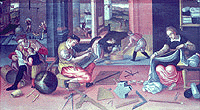

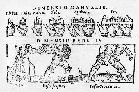 Figure 2
 Figure 3
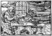 Figure 4
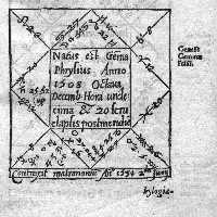 Figure 5
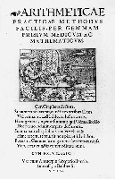 Figure 6
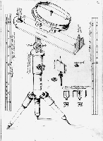 Figure 7
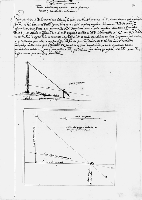 Figure 8
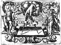 Figure 9
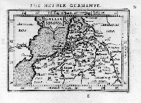 Figure 10
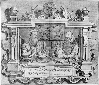 Figure 11
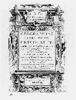 Figure 12
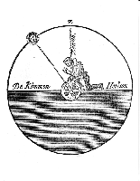 Figure 13
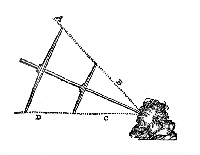 Figure 14
 Figure 15