| Home |  | Exhibition | | Catalogue | | Gallery | | Reconstruction | |
| .There was much discussion before the 18th-century transits of the best places from which to make observations. Several authors compiled maps to help in the decision-making process.
. This sheet has a more didactic and popular purpose. It is intended to explain the visibility of a transit, and shows three views of the Earth at different moments during the transit of 1761. The views represent the face of the Earth illuminated by the Sun at the beginning, middle and end of the transit. By inspection it is possible to estimate how much of the transit will be visible at any particular place. . Published by Benjamin Martin as a single broadside sheet for a potentially large public, this print is nevertheless exceptionally rare: there are no other known surviving copies. | 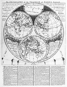 |