|
|
|||
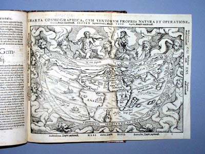
| In 1520 Petrus Apianus published a map of the world based on the one done by Waldseemüller in 1507. The Waldseemüller map is known from a single example and the 1520 Apianus derivative map is exceedingly rare. Gemma Friseus made a world map published in Louvain in 1540 and this map is now lost. The map shown here, appearing in editions of Cosmographia from 1544 on, is by Gemma Frisius and is probably based on these antecedent or mother maps. | |||
 click for larger image |
|||
|
The projection used in this world map is known as a cordiform projection since its outline resembles that of a heart. The cordiform projection was one of many different projections employed early in the history of cartography. The projection is truncated and the southern tip is cut off so we don't see whether Gemma Frisius attempted to depict the hypothetical antarctic continent. There is but a suggestion of it south of the Straits of Magellan. Despite the far more complete knowledge of the shape of North and South America already available when this map was made, it continued to use the outdated ribbon-like figure of the New World that dates back to the 1507 Waldseemüller map. However, this appears to be the first printed map that shows the true peninsular nature of Yucatan, in Central America. Earlier maps, and even the contemporary map by Sebastian Münster, with a much more up-to-date depiction of the New World, showed the Yucatan as an island. Although knowledge of geography was evolving rapidly and though many of the landforms are shown accurately proportioned, much remains distorted and some land masses such as Australia have yet to be discovered by European explorers. One of the figures at the top wears the double-headed eagle of the Holy Roman Emperor and the map itself is surrounded by allegorical windheads. The Ptolemaic climates are indicated along the left. Although three different blocks were cut to print the map during the decades it remained in print, the map was never revised. |
|||
|