|
|
|
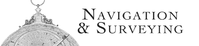
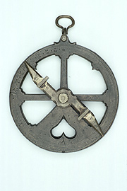
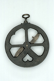
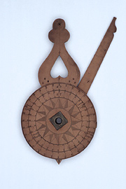
NAVIGATION The main tools of the navigator before the fifteenth century AD were personal experience and the magnetic compass, sounding line and hourglass. Navigation was only moderately certain on even the well established routes. But Prince Henry the Navigator of Portugal (1394-1460) embarked upon an ambitious exploration program that led to the adaptation of astronomical instruments, including the astrolabe, for navigation. The mariner’s astrolabe was sturdier than its terrestrial counterpart and typically used simpler scales. The distance sailed could be calculated by using it to measure the altitude of the Pole Star, or of the Sun at noon, and then comparing that with the known altitude of those bodies at port. (The nocturnal, of a similar design, was used to find the time at sea by the orientation of the stars.) Mariner’s astrolabes are much rarer today than other types of astrolabes both because they were often of humbler materials and because some ended up at the bottom of the sea.
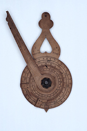
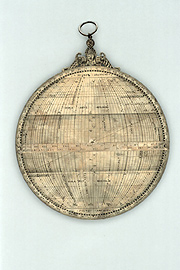
SURVEYING Some European instrument makers and mathematicians explored the use of the astrolabe for surveying, too. As with navigation, surveying required simpler features than did astronomy and astrology. The backs of astrolabes intended for this use typically include a “shadow square,” of a horizontal scale called the umbra recta and a vertical scale called the umbra versa. These were graduated lines representing the shadows cast by vertical and horizontal gnomons, as on a sundial. The astrolabe’s alidade could be used to take the angular measurement of the height of an object such as a tower. And then the lines of the shadow square, the height of the tower and its distance to the observer formed triangles that could be used to trigonometrically find the actual height. The same procedure could be used to determine distances or the depth of wells. In this sense, the astrolabe was a useful tool for the architect, artist or soldier as well as the surveyor.
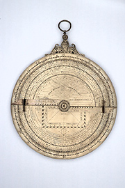
TRIANGULATION A method of using the astrolabe in map-making was also developed by Gemma Frisius (1508-1555) the famed physician, mathematician, cartographer, and globe and instrument maker. He attached his treatise on this traingulation method to all of the editions of Apianus’ Cosmographia that he published after 1533. The Cosmographia was one of the most popular contemporary astronomy textbooks. Frisius suggested using the astrolabe horizontally, oriented with a compass, to take the bearings of terrestrial landmarks. (Makers including his nephew, Gualterus Arsenius (fl. 1555-75), began to add compasses to their astrolabes.) Frisius would then choose two positions, take the bearings from them to a series of landmarks, and measure one of the distances between. This created a network of proportional triangles, as in surveying, that could be used to build a map of a territory |
||||||||||
|