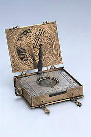
The compendium is in the form of a book, with two covers and a central box. The spine is suitably curved and bears two projections representing the bindings; the outward edges of the central box are engraved with lines to give the appearance of pages; two book clasps fasten it shut. A fixed suspension ring is attached to the upper edge.The outer face of the top cover carries a geographical astrolabe. A rotating circular plate (diameter 44 mm) carries a longitude scale of degrees 0 to 360 at its outer edge, divided to 10 and 2, and numbered by 10. Within the scale is a polar projection of the earth to the Tropic of Capricorn, with the tropics and the equinoctial named. The continents are named but schematically shaped, and there is no major North American land mass. The oceans are not named. The line of zero longitude begins not to the west of Africa as in other Schissler geographical astrolabes (Epact 57238) but lies within the western portion of Africa; it is numbered with a latitude scale at 10? intervals.
The plate rotates over a scale of hours I to XII, I to XII, each hour divided to 1/4. In each corner of the cover is a wind-blowing cherub head.
Above the geographical plate is a rete representing the ecliptic. The signs are indicated by their symbols, divided to 10 and 2, and numbered by 10, although the symbol invariably and to economise on space the signs from Aries to Virgo use 2 and 3 in place of 20 and 30. The rete has two supporting struts, one marked 'ZODIACI', the other 'SIGNORV'. It also has three points which terminate in small circular indicators. Two of these indicators move over the circle of the tropic of Cancer, the other moves over the equinoctial circle.
Above the rete is an index (now detached) marked for north ('LATI. SEP:') and south latitudes ('LATI. MERI:'). Running to 23? south, it is numbered by 10 and variably subdivided depending on the space available.
The reverse carries a map surrounded by a circular compass rose marked in French for 16 directions (rather than the 12 directions common on Schissler's German instruments). The names of the compass points are generally abbreviated and there is one apparent slip: north by north west is rendered only as 'NO NO:'. Around the wind rose are four wind-blowing cherub heads.
The map is centred in the middle of France and reaches to the Pyrenees in the south and Switzerland and Italy in the east. The towns are indicated by circular indentations (as on Epact 63321). A radial index carries a cursor sliding in a slot. The cursor in turn holds a rotating rule with arrow heads at either end to indicate the relative bearings of different towns. A central hole would have accommodated a wind vane, now missing.
The central box holds a horizontal string-gnomon sundial adjustable for latitude in the range 38 to 55?. The dial is of an unusual form. It has three loose silver plates, each side of which is engraved with hour lines spanning a latitude interval of three degrees. The hour scales run 4 to 12 to 8 with each hour divided to 1/2 and dotted to 1/4.
The string is held by a detachable support which, lacking provision for varying the height of the attachment point, is presumably a replacement. The support is held in place in a slot. At the other end, the string passes through a small cylinder to the underside where it is wound around a spring barrel to keep it taut.
The plates are all pierced with a circular aperture through which the compass is viewed. The compass bowl is 18 mm in diameter and the silvered base plate has a direction cross marked 'SE', 'ORT', 'ME', 'OCC'. The needle terminates in a T at north.
The compass is set within a compass rose decorated with enamel coloured pointers and marked in abbreviated French for 16 directions (north by north west is now 'N.N.OV'). Between each direction is a wind-blowing head in profile.
The underside of the compass rose and plate carries the compass bowl and the spring barrel. There is no table of latitudes. The surfaces are decorated with foliage engraving and there is a cockerel in the middle of the base of the compass bowl.
The inner face of the back cover carries a lunar volvelle. Around a fixed outer scale of hours I to XII, I to XII, divided to 1/2, is the title 'INCREMENTVM ET DECREMENTVM LVNNA'. The edge of the silver volvelle is cut away to reveal a scale for the age of the moon 1 to 291/2 and there is a circular aperture to display the phases of the moon, with a face at full moon. The volvelle's scale of hours runs 1 to 12, 1 to 12 without subdivision and surrounds a diagram of aspects inscribed with an equilateral triangle, square and hexagon, and the symbols for trine, quadrature and sextile. The surrounding foliate decoration includes two stork-like birds.
The back cover has an orthographic ('Rojas') projection of the sphere similar to those on other Schissler instruments (Epact 63321). The central band of parallels of declination between the tropics carry familiar forms of the names of the zodiacal signs. However, unlike other examples, this device can be used to determine not just the time of sunrise and sunset, but also dawn and twilight, for any latitude. The rotating index has a double scale of degrees 0 to 90 to 270 to 360 along its length, divided and numbered by 10, and subdivided as space allows. The index is also marked 'LINEA AVRORAE VEL CREPVSCVLINA' against the edge representing a small circle of 18? declination. Near one tip of the index is a circular hole, placed at the edge of the projection and reminiscent of the plummet suspension point on the sundial form of this projection (Epact 74519).
Above and below the projected zodiac band are the inscriptions 'HORAE ORTVS SOLIS' and 'HORAE OCCASVS SOLIS' respectively. There is space to number only the hours 1 to 11. The north and south poles are marked 'PO: ARC.' and 'PO: ANTA' and around the circumference is the latitude scale 0 to 90, 0 to 90, 0 to 90, 0 to 90 (rather than 0 to 90 to 0 to 90 to 0). This scale is marked 'GRAD. ELEVAT: POLI' and divided to 10 and 2, and numbered by 10. The edges of the plate carry foliate engraving.
Stephen Johnston